
Emerald Necklace Cleveland Ohio
 The Cleveland Metroparks were established in 1917, long before the phrase "linear park" was coined by contemporary trail builders. But many of the parks have been lined up nicely for many years, linked by parkway roads and trail that ties together and forms this unique trail system.
There are other reservations that are not connected directly to the necklace, while the Big Creek Reservation is an offshoot that is linked by trail.
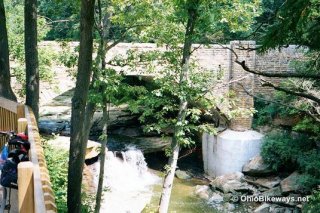
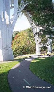
The scenery is quite beautiful along much of the trail. It seems that every few hundred yards or so there is something to catch your eye. Vertical hillsides scattered with rocks, mammoth-sized highway bridge trestles, trail bridges over rivers, soccer games and family picnics - the sights are numerous and varied as you make you way through the parks.
On our 2009 visit, we puzzled over how our ride approached 100 miles over two days. With sag support, we didn't have to double back, so an extra 30 miles seemed extreme. Initially it was thought the reported mileage did not include the parkway road riding necessary to link between trail sections. But a mileage check with a mapping program revealed that 70 miles is fairly accurate.
We did an out-and-back ride to the Big Creek Reservation, so that added several miles. Short excursions exploring a few spurs, making a couple wrong turns, riding an unnecessary loop at the South Chagrin Reservation, it all added up. But we could still only account for about 83 of our 96 miles logged.
It's safe to say that you can expect to ride more than the advertised mileage here, particularly if you're not carrying good maps!
 The condition of this huge trail network varies quite a lot due to the periodic resurfacing of older segments and the occasional addition of new segments or spurs. So the surface runs the gamut from poor to excellent condition, while the width of the trail is also subject to change with many older sections being narrower.
In 2009, the poorest conditions were en route to and in the Big Creek Reservation (some heavily cracked and deteriorated asphalt) and the North Chagrin Reservation (large "cupping" in the center of the trail with cracks alongside, probably due to an inadequate base for the asphalt). With a good fat-tire machine, none of these older sections should be a problem. And you can manage it with skinny tires, albeit more slowly.
On a previous visit we reported that water was difficult to find in some parks. That is no longer the case as latrines with antibacterial soap and nearby water fountains were commonplace.
Emerald Necklace - Western Section
We revisted the trail in July, '09 and followed the same west to east route as before by starting at the northwest end of the bikeway at the Rocky River Reservation in Lakewood at Detroit and Sloane Avenues. Entering the reservation you descend into the Rocky River Valley which is at the bottom of a deep ravine. The paved trail snakes along between the Valley Parkway Road and the river, which accompany you on your ride.
 The trail travels through wooded areas and over and along several hillsides. This allows for some natural obstacles on the trail surface. Extreme caution is recommended when riding after a heavy rain, particularly in the fall when wet leaves and nuts can be a real hazard. Mud slides are also possible in some sections.
The Emerald Necklace Trail is not a rail-trail and therefore it is not a flat or straight bikeway. The trail winds its way along much like a snake's track in the sand. This snake-like path quickly challenges your riding skills by taking you up and down small hills and through an assortment of curves of varying degrees of sharpness. The asphalt path is quite narrow at only 8-9' wide, which makes negotiating the terrain while passing other trail users quite challenging. The trail provides a very technical ride if you attempt to cycle at more than just a leisurely pace, which is not recommended. This is a leisure trail intended for pleasant slow-speed rides through wooded areas.
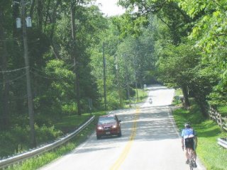
Road bikes are a bit out of place on the trail. Most trail riders use mountain or hybrid bikes, while the roadies take to the Valley Parkway which parallels the trail. There they can pickup more speed and ride in more of a straight line.
 On our most recent visit, the western section of bikeway had one continuous asphalt path from Lakewood, at the start of the Rocky River Reservation, to the Stuhr Woods Picnic Area, just west of Ridge Road. This 25-mile section runs out near the top of a challenging climb at the picnic area. After summiting on the parkway road, it's an easy 5.75 miles along the Valley Parkway until you cross Rt. 21 where the trail picks up again at the Brecksville Reservation.
However, if you're inclined to explore the new Lake-to-Lake Trail that connects Lake Abram and Lake Isaac, you'll want to turn north onto the trail at the Big Creek Parkway. This connector is just south of the I-80 underpass along the trail in the Mill Stream Run Reservation. Exploring the entire Big Creek Reservation trail adds about 15 trail miles (7.5 up and back), while exploring the Lake-to-Lake path should be a bit less.
Take note that at the time of this review much of the Big Creek Trail section was in poor to fair condition with deteriating asphalt sections and some heavily cracked tarmac as well. But unless you're on a skinny-tire road bike, this shouldn't pose any problems. We managed it on skinny rubber, but it's not much fun.
We found the road riding along the parkway to the Brecksville Reservation to be a pleasant one. The posted speed limit of 30 mph, along with the courtesy displayed by local drivers who seemed accustomed to bicycle traffic along this road, made the ride a lot less scary than riding on a rural highway or busy city streets.
If you're used to riding flat trails, however, the Emerald Necklace provides quite a challenge. Though the trail does have some flat sections, most often you'll be climbing or descending in and out of the valley or along its hillsides.
There are a number of connecting paths that you'll encounter along the way. Most are not signed, so at times you won't be sure which is the main trail. Sometimes a marker will tell you where a spur goes, but you won't know how far the trip is.
An attempt was made at some point to paint distance and destination markers on the trail surface. But many have faded over time and the legible ones provide destination names that may hold little meaning for visitors.
india amazon india bazaar india bazaar near me india bistro india batson india birth rate india bazaar frisco india bhavan india bazaar irving india covid india covid cases india cricket india china india coronavirus india currency india covid deaths india capital india defence news india de beaufort india delta variant india date and time india durk india diwali india diwali 2021 india demographics india eisley india england india economy india e visa india england cricket india england test series india etf indian visa india flag indian food near me india facts india flights india foxtrot india flavors india forums india gdp india garden india gate india gdp per capita india government india grocers india grill india gants india house india holidays 2021 india hemsworth india holidays india hicks india house chicago india hut india house santa fe india ink india independence india income tax india india india international flights india inflation rate india independence day india imports indiana jones india jewelry india joze india jersey india johnson india japan indiana jones 5 india jewelry online india ka india kager india kitchen tustin india ka match india kashmir india k raja india ka map india kitchen watertown india love india language india love age india local time india lil durk india life expectancy india location india literacy rate india map india maria india match india mart india market india money india map states india metro hypermarket india newsShare this article
Related Posts


Latest Posts


